Environment
A series of studies are being prepared in relation to the environmental aspects of the proposed quarry extension.
The findings are informing and shaping the proposals seen here today to ensure they minimise the impact on people, wildlife, the landscape and other environmental factors such as surface and ground water during the operation and future management of the extended quarry.
Ecology
Significant consideration has been given to the possible effects of the quarry extension on the ecology of the site. Wildlife and protected species surveys are currently being undertaken and are due to be completed by the end of December to determine features of ecological value within and immediately adjacent to the site.
These include:
- Extended Phase 1 Habitat Surveys;
- Great Crested Newt Survey;
- Reptile Survey;
- Bat Roost Survey;
- Bat Activity Survey;
- Dormouse Survey;
- Badger Survey
- Breeding Birds Survey; and
- Full Wintering Bird Survey.
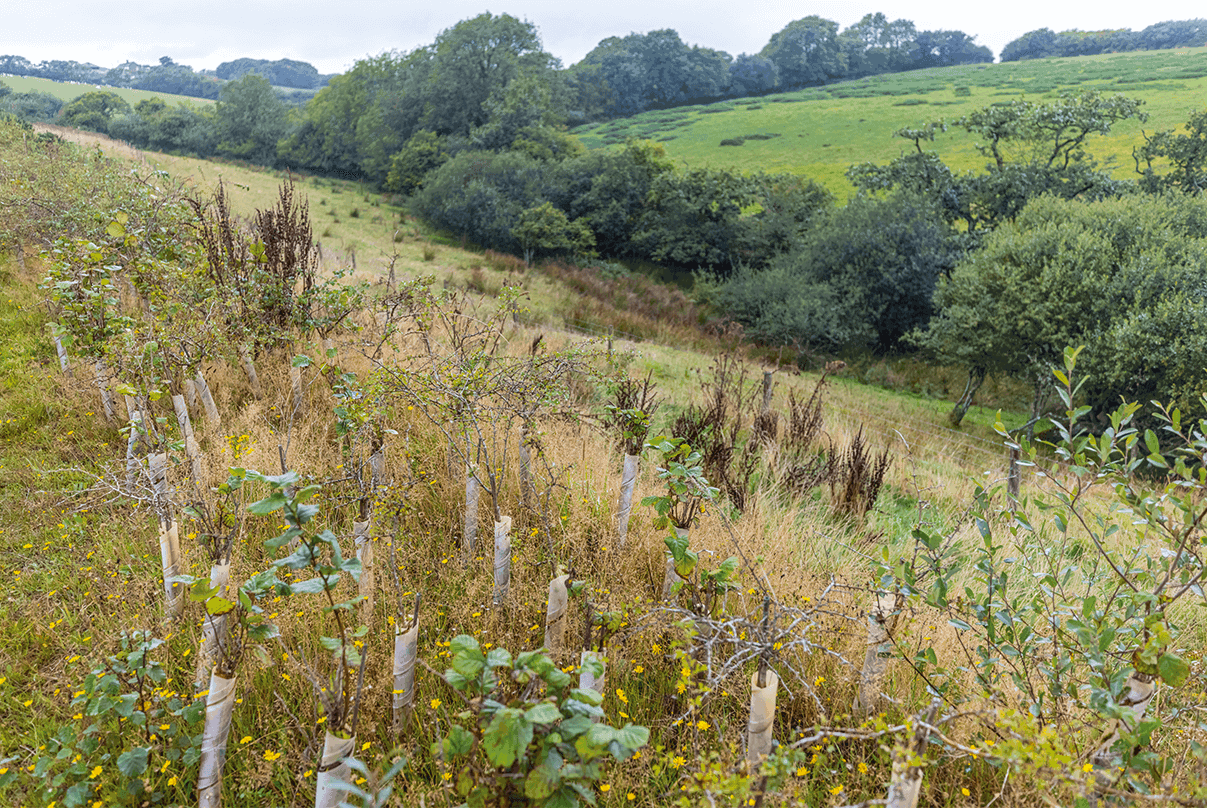
The results of these surveys will be fed into the Landscape and Ecological Mitigation Strategy plan which will seek to avoid or reduce impacts on wildlife and maintain habitat connectivity around the quarry extension and within the wider surrounding landscape. The Strategy will include where Biodiversity Net Gains (BNG) have been accommodated on and off site. This will include translocating c. 0.5km of existing hedgerows, planting of 0.45 km of new hedgerows, creating more than 6ha of species-rich grassland and more than 2ha of new woodland and scrub.
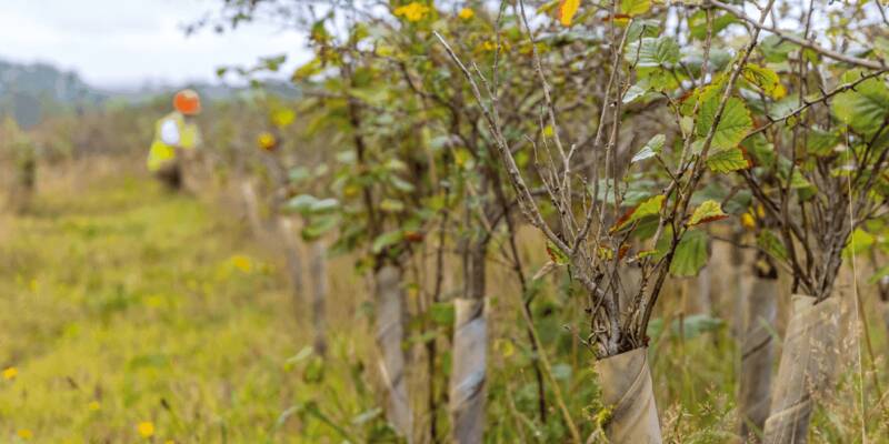
The Strategy will also set out measures to minimise impacts and provide enhancements for protected and notable species, including Dormice, bats, reptiles and breeding birds which will include:
- Works to dormouse habitat would be undertaken under
- a Natural England mitigation licence;
- Timing of works, in particular vegetation clearance /
- hedge translocations to avoid sensitive periods for wildlife;
- Ecological supervision of vegetation clearance / hedge translocations, as well as ongoing monitoring during construction and operation;
- Provision of new habitats including woodland, scrub, species-rich grasslands and hedgerows to improve habitat availability and connectivity in the longer term; and
- Installation of artificial refuges for wildlife, including dormouse nest boxes and bat boxes on trees.
A Landscape and Ecology Management Plan, which will include a Biodiversity Management Plan, will be implemented to ensure the biodiversity value of created and retained habitats is maintained in the long-term.
Landscape and Visual
Pigsdon Quarry is not located within any landscape
designations but does fall within the setting of the locally protected
Gooseham to Launcells Area of Great Landscape Value (AGLV). The AGLV
lies approximately 0.3km west of the site with the B3254 forming its
eastern boundary near Lewdon Farm and Rhude Cross.
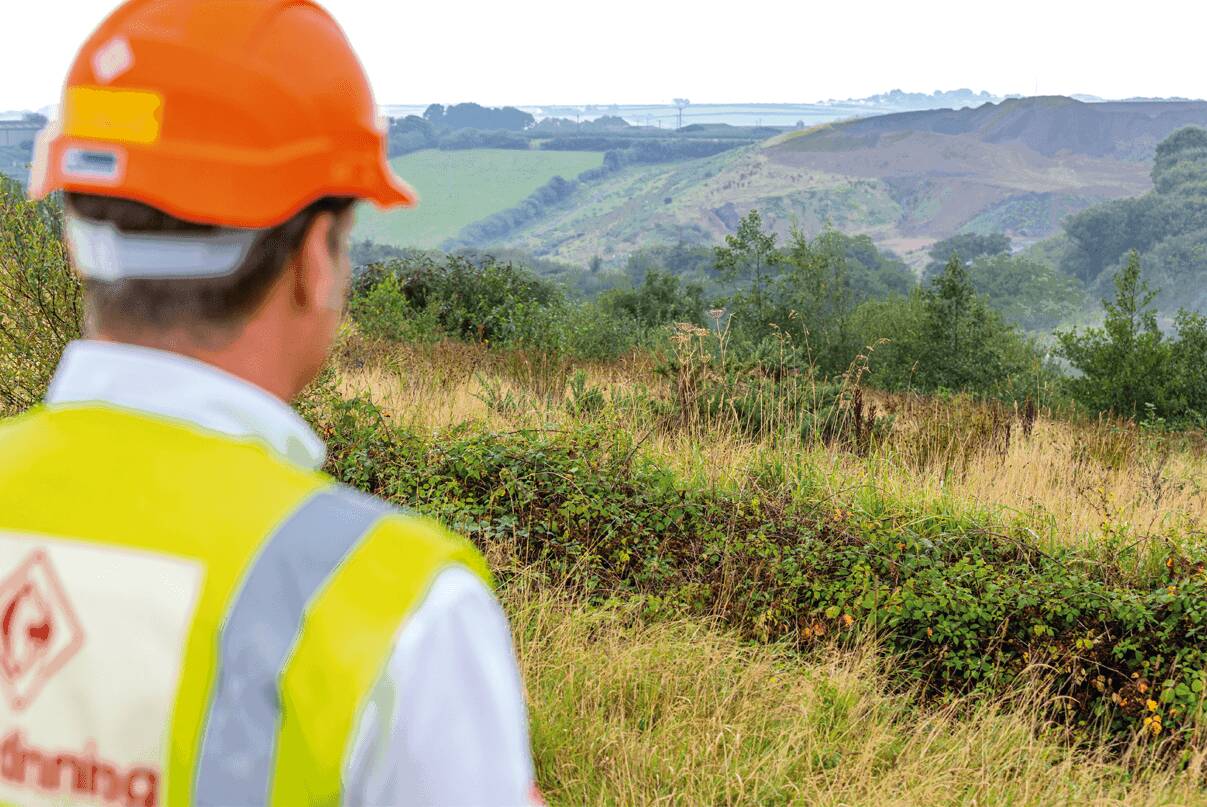
The existing quarry is located in a sparsely settled rural landscape. The proposed extension to the quarry is likely to result in localised landscape character changes. This in turn is likely to affect the character of views within a localised area and therefore a Landscape and Visual Impact Assessment will be prepared to assess this.
In response to the potential impacts, a ‘work in progress’ Landscape and Ecological Mitigation Strategy plan has been prepared which shows measures taken to avoid or reduce potential impacts that may result from the proposal. The mitigation is presented in two stages.
The first is what could be delivered alongside the quarry when in operation (at around 20 years). The second is what could be delivered as part of the final restoration of the quarry when operations cease. The mitigation measures presented include where existing hedges could be translocated, where new hedgerows and woodland could be planted and where ditches and ponds are required to catch surface water run-off.
Historic Environment
There are no designated heritage assets, such as Listed Buildings or Scheduled Monuments within the site, or in the near vicinity of the site. However, the potential for non-designated heritage assets or buried archaeology within the quarry extension and overburden placement areas have been investigated.
Specialist consultants AC archaeology have been appointed to assess the impacts of the proposals on any potential archaeological features within the site. A Geophysical Survey has been carried out showing generally low-level results, with some findings requiring further testing through trial trenching. A report will be prepared from the trial trenching and any necessary mitigation measures will be proposed if required.
A Heritage Impact Assessment, including a Historic Landscape and Visual Impact Assessment, will also be prepared to support the planning application. This will assess any potential effects on any heritage assets within or adjacent to the site and on any potential buried archaeological remains, providing appropriate mitigation measures if needed.
Water Management
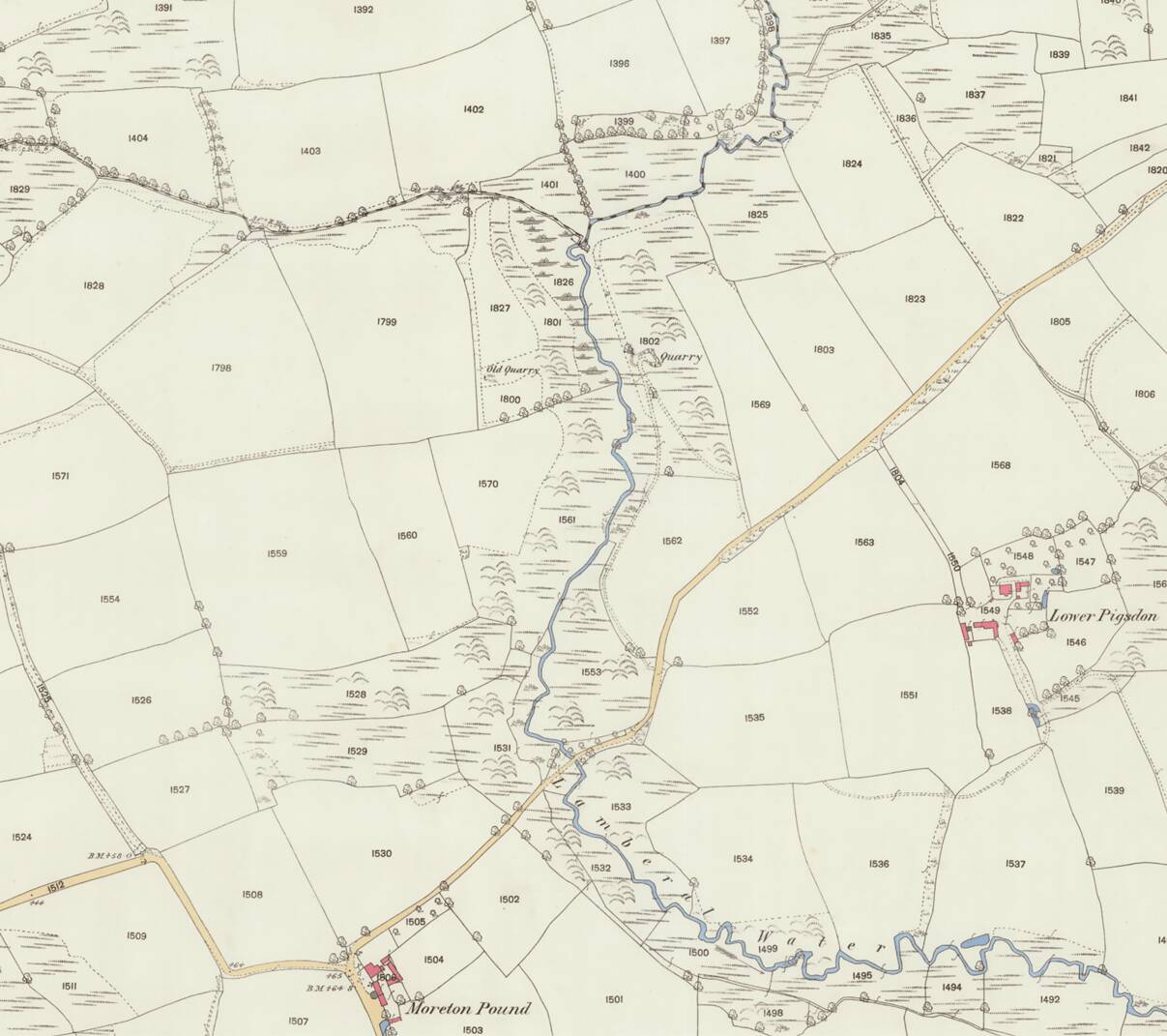
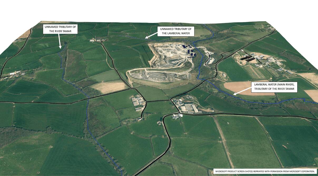
Proactive water management is highly important to ensure operation of the quarry, and protection of existing water features. The quarry extension area or the overburden placement fields do not intercept any existing watercourse.
Flood Risk
The proposed land for the quarry extension and placement of overburden are located in Flood Zone 1 i.e. not at risk of fluvial flooding from the Lamberal Water, located to the east, or other watercourse.
Surface Water Runoff and Groundwater
Surface water runoff from the extended quarry will increase the volume of rainfall water and groundwater inflow requiring discharge to the Lamberal Water, though that is considered a ‘transfer operation’ because without the quarry that water would have naturally flowed towards the Lamberal Water. Attenuation storage can be provided within the quarry void and the discharge to the Lamberal Water will be at a controlled rate agreed with the Environment Agency. As the discharge can be attenuated within the quarry void, the main consideration will be ensuring the discharge quality remains acceptable with regard to suspended solids and other substances. The quarry has a permit to discharge and an abstraction licence, which will be updated to include the quarry extension area.
Impact to a nearby abstraction is not foreseen because the potential for an impact will be predicted by monitoring a long time before an impact actually occurs, with the quarry operations adjusted to prevent or mitigate an impact. Notwithstanding that there is also a plan for the provision of alternative water supplies that has been agreed with the planning authority.
The fields for overburden placement, slope towards and therefore drain surface water run off to the west to an ordinary unnamed watercourse with a catchment of approximately 0.57 square kilometres to the bridge over the watercourse where it passes under the minor road between Rhude Cross and Moreton Pound. The overburden placement will change the slope of the existing fields which will increase the surface water runoff. Therefore, appropriate attenuation storage for the increase in surface water run-off from the overburden fields will be included in the final design for planning submission to ensure no change in flood risk or water quality downstream.
Noise, Vibration and Dust
Noise, dust and vibration are actively managed in line with good practice when quarrying to minimise their impact and will continue to be managed in such a way as part of the quarry extension.
Noise
Noise levels within the quarry extension area will be a continuation of current levels which are within the quarry’s consented limits. The extension area and the overburden placement fields are closer to a number of residential receptors compared to the consented quarry extraction area. Noise modelling has been prepared to provide noise levels on those receptors from both the extraction of minerals and associated works in the extension area and the placement of overburden on the three fields to the west of Lopthorne Lane which will take place on a ‘campaign’ basis over 3-4 years for a maximum of 8 weeks between April and October. This will be carried out during the first few years of Phase 1.
Topsoil stripping and temporary placement elsewhere has also been modelled. A Noise and Vibration Impact Assessment will be prepared to support the planning application which will provide an assessment of any potential noise and vibration impacts to these receptors and provide mitigation measures if required.
At this stage, considered mitigation and control measures include the methodology for backfilling shale waste in Field B, with each layer being preceded by the formation of a screening outer edge bund to shield subsequent operations; limiting the duration of operations; formation of a noise screening bund adjacent Lopthorne Farm in Field S; and for worst-case overburden operations also limiting the number of activities being undertaken simultaneously and restricting working hours.
Vibration
Modern blasting is very sophisticated and levels of vibration are carefully controlled by modifying the following:
- Number of blast holes;
- Weight of explosives;
- Amount of stemming (inert backfill to a blast hole); and
- The blast timing sequence.
This means that blasting in the existing part of the quarry is well within the limits set by the current planning permission.
The blasting will continue to be controlled so the effects are a practical minimum and within authorised levels.
Dust
The main sources of dust in the quarry and its western spoil tip are the processing plant in the north-eastern part of the existing quarry, vehicle movements along haul routes used to transport gritstone to the processing plant or waste to the spoil tip.
As no increase to ongoing production levels is planned, there will be no material changes in the number of vehicle movements to or from the quarry. Hence there is expected to be no significant effect on air quality with continued pro-active dust mitigation measures applied by the quarry operator.
Fugitive dust emissions during the quarry extension and overburden placement will continue to be controlled as for the existing quarrying operations, by adopting best practice, implemented under the quarry’s Dust Management Plan which will be updated to address the proposed extension and overburden placement.
Haul routes for the extension will be slightly longer than they are at present, but normal dust control techniques still apply.
Typical dust control measures include avoiding dust generating activities when the wind direction could transport dust off site, and dust suppression by water sprays on haul routes and at the processing plant. The intensity of activity such as plant movements and overburden placement is also planned to minimise the risk of adverse dust dispersion, with restoration planting as soon as practical following completion of tipping in an area.